

Mustang Energy Corp. Provides Update on Geophysical Reinterpretation and Targeting
/EIN News/ -- VANCOUVER, British Columbia, May 02, 2025 (GLOBE NEWSWIRE) -- Mustang Energy Corp. (CSE: MEC, OTC:MECPF, FRA:92T) (the “Company” or “Mustang”) is pleased to provide an update on its ongoing geophysical reprocessing, reinterpretation and targeting work in collaboration with leading geophysical consultants Resource Potentials Ltd. (“ResPot”) of Perth, Australia. This initiative reflects Mustang’s commitment to advancing exploration across its Athabasca Basin uranium projects through cost-effective, technically sound data integration.
Geophysical Reinterpretation Methodology
Following a detailed historical data compilation, ResPot has reprocessed and interpreted a suite of high-resolution airborne magnetic, radiometric, gravity, and electromagnetic (“EM”) datasets over Mustang’s properties. These datasets were sourced from open-file surveys by provincial and federal agencies and integrated with digital elevation models, geological maps, mineral occurrence records, drilling and geochemical data, and satellite imagery in GIS software.
Magnetic datasets were utilized to infer the depth and architecture of the Athabasca Basin unconformity—a critical control for high-grade uranium mineralization. EM datasets, including VTEM, MegaTEM, GeoTEM, ZTEM, and VLF surveys, were processed to identify conductive anomalies potentially related to graphitic pelite units and clay alteration zones.
Ratios and products of radioelement concentrations (K, Th, U) were computed to enhance subtle radiometric anomalies, despite their susceptibility to attenuation by surface cover. The integrated interpretation has revealed multiple areas of interest coincident EM-magnetic-low anomalies characteristic of basement-hosted unconformity-related uranium deposits.
A key component of this work has involved the continuous interpretation of geophysical data to guide targeted mineral claim staking, alongside the review of internal and public datasets, as Mustang evaluates potential project acquisitions and joint venture opportunities.
In addition to the reprocessing, reinterpretation, and targeting of historical datasets, ongoing interpretation is also underway on newly acquired airborne geophysical surveys. These include a MobileMT survey recently completed over the Yellowstone Project and an Xcite™ TDEM survey over the Dutton Project. Further analysis will also be conducted on the upcoming Xcite™ TDEM survey with radiometric data acquisition planned for the Spur Project in May. These contemporary datasets are expected to complement the historical compilation work and enhance Mustang’s ability to prioritize drill-ready targets across its portfolio.
Targeting:
The work conducted thus far, has resulted in targeting based off of the open source geophysical datasets over Mustang’s Athabasca Basin Uranium portfolio. Areas of interest have been identified based on this reinterpretation:
914W Project:
Positioned approximately 45 km south of the Athabasca Basin edge, this project hosts an EM conductor anomaly coinciding with a magnetic low and subtle radiometric uranium signature (Figure 1). Furthermore, the project lies along trend with known uranium and REE occurrences. The company plans to initiate a field-based prospecting program this spring to further assess these priority targets.
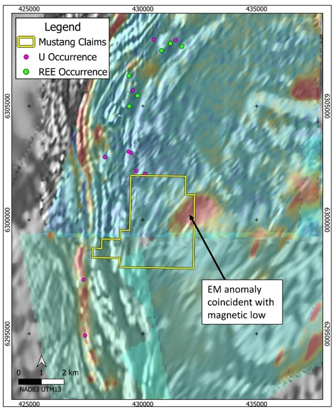
Figure 1: 914W Project claim and mineral occurrences over a mosaic EM decay colour image from 3 adjacent airborne EM surveys where hot colours indicate electrical conductors, all overlying greyscale magnetic derivative background image. An EM conductor of interest is coincident with a magnetic-low anomaly and is considered to be a priority target area. (map layers retrieved from: Government of Saskatchewan Mining and Petroleum GeoAtlas and Natural Resources Canada)
https://www.globenewswire.com/NewsRoom/AttachmentNg/2be644cd-6cf3-43ad-a5db-6285951dd567
Spur Project:
Located about 30 km south of the Basin, Spur is intersected by regional magnetic-low and EM conductor trends (Figure 2). Radiometric anomalies are evident, though muted by surface cover. Mustang has engaged Axiom Exploration to deploy the Xcite™ TDEM system with co-collection of radiometrics to in-fill areas not covered by modern day EM survey techniques. This project, like 914W, is also considered prospective for REE mineralization based on regional occurrence trends.
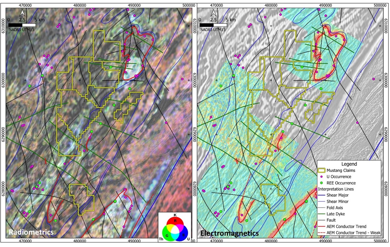
Figure 2: Spur project claims, mineral occurrences and select interpretation lines over a ternary radiometric image (left) where K is red, Th is green and U is blue, and late EM decay time images from 3 adjacent airborne EM surveys (right) where hot colours indicate electrical conductors, all overlying greyscale magnetic derivative background images. Note that this are no available EM datasets over the main part of the Spur claim. (map layers retrieved from: Government of Saskatchewan Mining and Petroleum GeoAtlas and Natural Resources Canada)
https://www.globenewswire.com/NewsRoom/AttachmentNg/554ad7e4-df56-4e6a-8069-96d1c0f51ba6
Ford Lake:
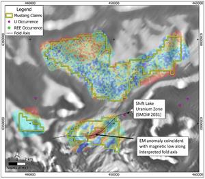
Comprised of 3 non-contiguous claim blocks and located within the Basin near the southern edge, with interpreted depths to the unconformity at ~400 meters or less. Ford Lake features a strong, untested EM conductor anomaly coincident with a magnetic-low trend. This anomaly is spatially associated with a known uranium occurrence to the northeast2 and a subtle U-Th radiometric trend. Follow-up mapping and sampling are recommended (Figure 3).

Figure 3 : Ford Lake project claims and mineral occurrences over a mosaic VTEM EM decay colour image from 3 separate airborne EM surveys where hot colours indicate electrical conductors, all overlying greyscale magnetic derivative background image. An EM conductor of interest is coincident with a magnetic-low anomaly and located along an interpreted fold axis from a known U occurrence. (map layers retrieved from: Government of Saskatchewan Mining and Petroleum GeoAtlas and Natural Resources Canada)
https://www.globenewswire.com/NewsRoom/AttachmentNg/53a63b94-b215-4e3a-82db-40810ac3be19
Cigar Lake East:
Comprised of 2 non-contiguous claim blocks and located within the Basin near the eastern edge, with interpreted depths to the unconformity at ~200 meters or less. Cigar Lake East features multiple parallel NE-SW trending magnetic-low trends, some of which have been historically drill tested and host U mineralisation, including the Rabbit Lake Uranium Mine located approximately 40km to the NE. A magnetic-low anomaly trend within Mustang claims is coincident with EM conductor anomalies and remains untested by drilling.

Figure 4: Cigar Lake East project claims, historic drillhole collars and mineral occurrences over a mosaic VTEM EM decay colour image from 2 separate airborne EM surveys where hot colours indicate electrical conductors, all overlying a greyscale magnetic derivative background image. An EM conductor of interest is coincident with a magnetic-low anomaly trend that has not been historically drill tested, along trend from the Rabbit Lake U Mine and adjacent to known mineralised trends. (map layers retrieved from: Government of Saskatchewan Mining and Petroleum GeoAtlas and Natural Resources Canada)
https://www.globenewswire.com/NewsRoom/AttachmentNg/93bc8e68-1359-4e0a-b339-788ca018424a
“Our partnership with ResPot has yielded valuable insights that advance Mustang’s uranium exploration strategy,” said Nicholas Luksha, CEO and Director of Mustang Energy. “By leveraging existing datasets and high-end geophysical modelling, we are refining drill targets while optimizing exploration spend. These interpretations form the basis of our 2025 field program and inform our ongoing project evaluation efforts.”
All geophysical data contained in this news release is not definitive, and the results are still at an early stage of interpretation, with no guarantee of a mineral discovery.
About Resource Potentials:
Resource Potentials Ltd. is a consulting and contracting business specialising in geophysical survey design, acquisition, processing, modelling, inversion, data integration, interpretation and drill hole targeting. Based in Perth, Western Australia and established in 2001, ResPot provide their clients with expertise and products that fit their requirements and budgets for exploration, drilling and mining operations. ResPot is highly experienced in processing, interpreting and modelling potential field (magnetic and gravity) and other geophysical surveys such as radiometrics, EM, IP, GPR and seismic data in a variety of geological settings for commodities including; gold, iron, base metals, uranium, REE, manganese, coal, diamonds, oil and gas, groundwater, etc.
Qualifying Statement:
The scientific and technical information in this release has been reviewed and approved by Lynde Guillaume, P.Geo., Technical Advisor for Mustang Energy, and a registered member of the Professional Engineers and Geoscientists of Saskatchewan. Ms. Guillaume is a Qualified Person as defined by National Instrument 43-101 - Standards of Disclosure for Mineral Projects.
About Mustang Energy Corp.:
Mustang Energy is a resource exploration company focused on acquiring and developing high-potential uranium and critical mineral assets. The Company is actively exploring its properties in Northern Saskatchewan, Canada and holds 92,211 hectares in around the Athabasca Basin. Mustang’s Ford Lake project covers 7,743 hectares in the prolific eastern Athabasca Basin, while its Cigar Lake East and Roughrider South projects span 3,442 hectares, and the south-east region with the Spur Project (17,929 hectares). Mustang has also established a footprint in the Cluff Lake region of the Athabasca Basin with the Yellowstone Project (21,820 hectares) and further expanded its presence in the south-central region of the Athabasca Basin with the Dutton Project (7,633 hectares).
For further information, please contact:
Mustang Energy Corp.
Attention: Nicholas Luksha, CEO and Director
Phone: (604) 838-0184
Neither the CSE nor the Market Regulator (as that term is defined in the policies of the CSE) accepts responsibility for the adequacy or accuracy of this release.
This news release includes certain statements and information that may constitute forward-looking information within the meaning of applicable Canadian securities laws. Forward-looking statements relate to future events or future performance and reflect the expectations or beliefs of management of the Company regarding future events. Generally, forward-looking statements and information can be identified by the use of forward-looking terminology such as “intends”, “believes” or “anticipates”, or variations of such words and phrases or statements that certain actions, events or results “may”, “could”, “should”, “would” or “occur”. This information and these statements, referred to herein as “forward‐looking statements”, are not historical facts, are made as of the date of this news release and include without limitation, statements regarding discussions of future plans, estimates and forecasts and statements as to management’s expectations and intentions with respect to, among other things, the future potential of the minerals claims held by the Company, the successful commencement and completion of the MobileMT survey, and the timely delivery of the results from the MobileMT survey. In making the forward-looking statements in this news release, the Company has applied several material assumptions, including without limitation the assumption that the Company will be able to: continue exploring its properties given various environmental and economic factors outside of its control and complete the MobileMT survey as planned. Although management of the Company has attempted to identify important factors that could cause actual results to differ materially from those contained in forward-looking statements or forward-looking information, there may be other factors that cause results not to be as anticipated, estimated or intended. There can be no assurance that such statements will prove to be accurate, as actual results and future events could differ materially from those anticipated in such statements. Accordingly, readers should not place undue reliance on forward-looking statements and forward-looking information. Readers are cautioned that reliance on such information may not be appropriate for other purposes. The Company does not undertake to update any forward-looking statement, forward-looking information or financial out-look that are incorporated by reference herein, except in accordance with applicable securities laws.

![]()
Figure 1

914W Project claim and mineral occurrences over a mosaic EM decay colour image from 3 adjacent airborne EM surveys where hot colours indicate electrical conductors, all overlying greyscale magnetic derivative background image. An EM conductor of interest is coincident with a magnetic-low anomaly and is considered to be a priority target area. (map layers retrieved from: Government of Saskatchewan Mining and Petroleum GeoAtlas and Natural Resources Canada)
Figure 2

Spur project claims, mineral occurrences and select interpretation lines over a ternary radiometric image (left) where K is red, Th is green and U is blue, and late EM decay time images from 3 adjacent airborne EM surveys (right) where hot colours indicate electrical conductors, all overlying greyscale magnetic derivative background images. Note that this are no available EM datasets over the main part of the Spur claim. (map layers retrieved from: Government of Saskatchewan Mining and Petroleum GeoAtlas and Natural Resources Canada)
Figure 3
Ford Lake project claims and mineral occurrences over a mosaic VTEM EM decay colour image from 3 separate airborne EM surveys where hot colours indicate electrical conductors, all overlying greyscale magnetic derivative background image. An EM conductor of interest is coincident with a magnetic-low anomaly and located along an interpreted fold axis from a known U occurrence. (map layers retrieved from: Government of Saskatchewan Mining and Petroleum GeoAtlas and Natural Resources Canada)
Figure 4

Cigar Lake East project claims, historic drillhole collars and mineral occurrences over a mosaic VTEM EM decay colour image from 2 separate airborne EM surveys where hot colours indicate electrical conductors, all overlying a greyscale magnetic derivative background image. An EM conductor of interest is coincident with a magnetic-low anomaly trend that has not been historically drill tested, along trend from the Rabbit Lake U Mine and adjacent to known mineralised trends. (map layers retrieved from: Government of Saskatchewan Mining and Petroleum GeoAtlas and Natural Resources Canada)
Distribution channels: Banking, Finance & Investment Industry, Mining Industry ...
Legal Disclaimer:
EIN Presswire provides this news content "as is" without warranty of any kind. We do not accept any responsibility or liability for the accuracy, content, images, videos, licenses, completeness, legality, or reliability of the information contained in this article. If you have any complaints or copyright issues related to this article, kindly contact the author above.
Submit your press release